🔥Get 3% Off Your First Train Ticket Booking!
As a special treat, Trip.com is offering a 3% discount on your first train ticket booking. Simply claim your coupon and enjoy a seamless travel experience.

Planning a trip to the "Avatar Mountains"? Navigating the 3,000 sandstone pillars of Zhangjiajie requires a detailed plan. Below, you will find Zhangjiajie maps covering the National Forest Park, Tianmen Mountain, and the Grand Canyon Glass Bridge, including transportation routes.
Source: Wikipedia
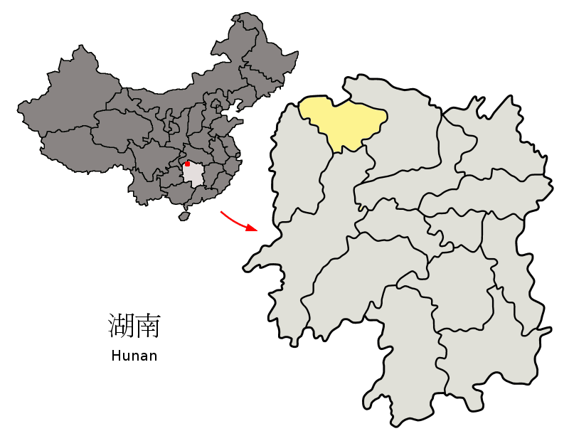
Zhangjiajie is located in north-west Hunan Province, central China, surrounded by dramatic mountains, forests and river valleys. On a China map, it sits inland, roughly between major cities like Changsha (the provincial capital).
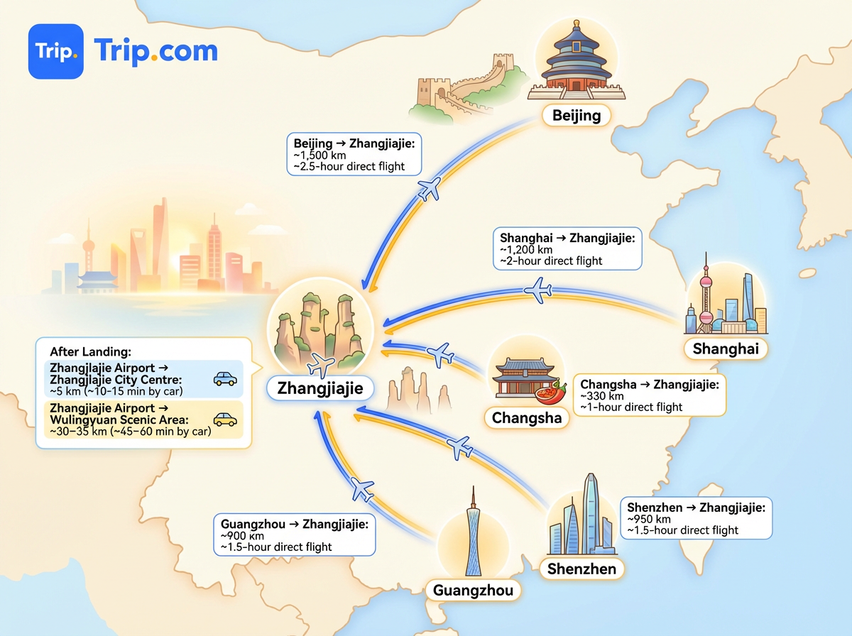
After landing, it’s 5 km to Zhangjiajie City Centre (~10–15 min by car) and 30–35 km to Wulingyuan Scenic Area (~45–60 min by car).
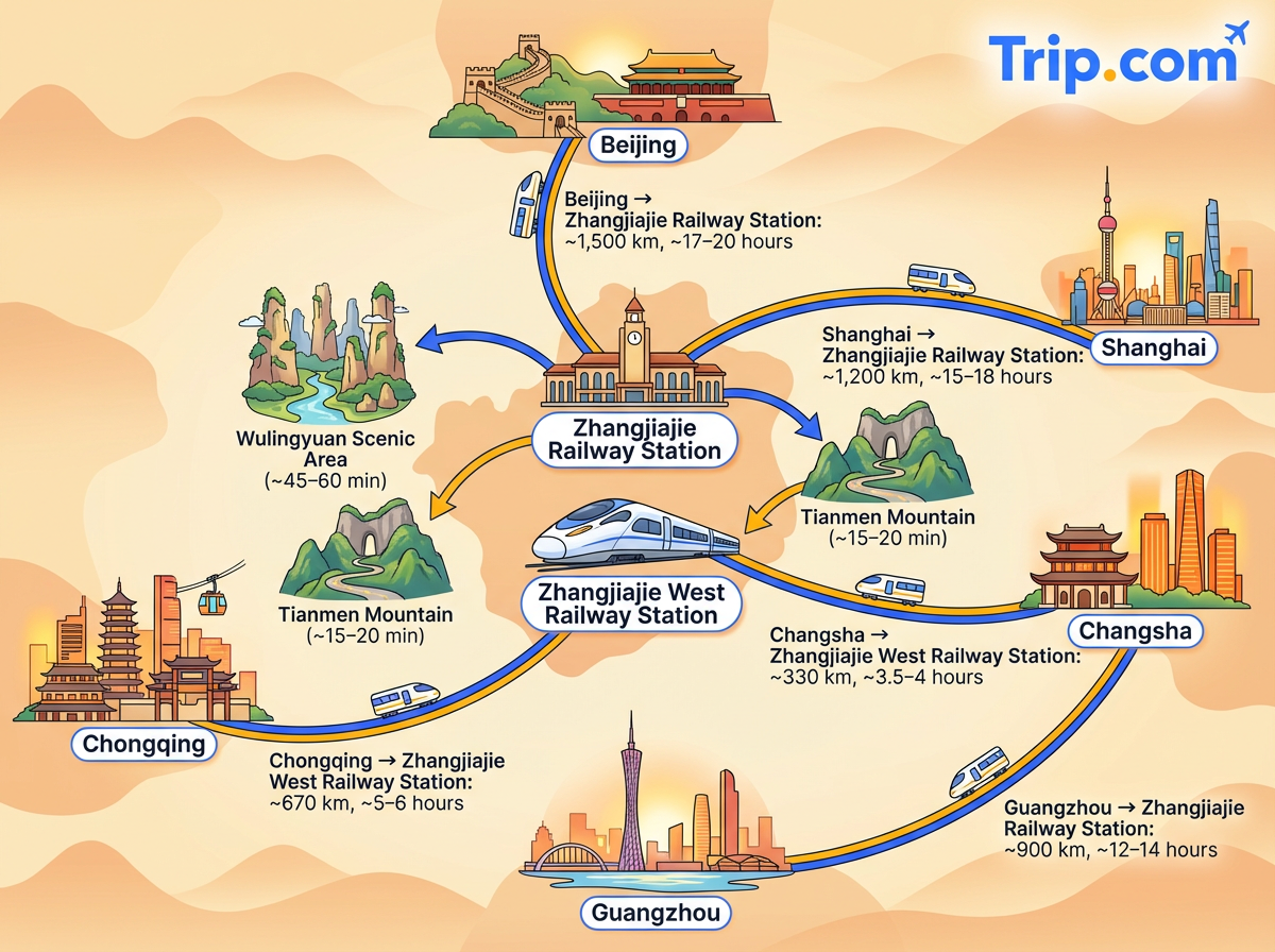
From both stations, taxis or buses can take you to Wulingyuan Scenic Area (~45–60 min) or Tianmen Mountain (~15–20 min).
As a special treat, Trip.com is offering a 3% discount on your first train ticket booking. Simply claim your coupon and enjoy a seamless travel experience.
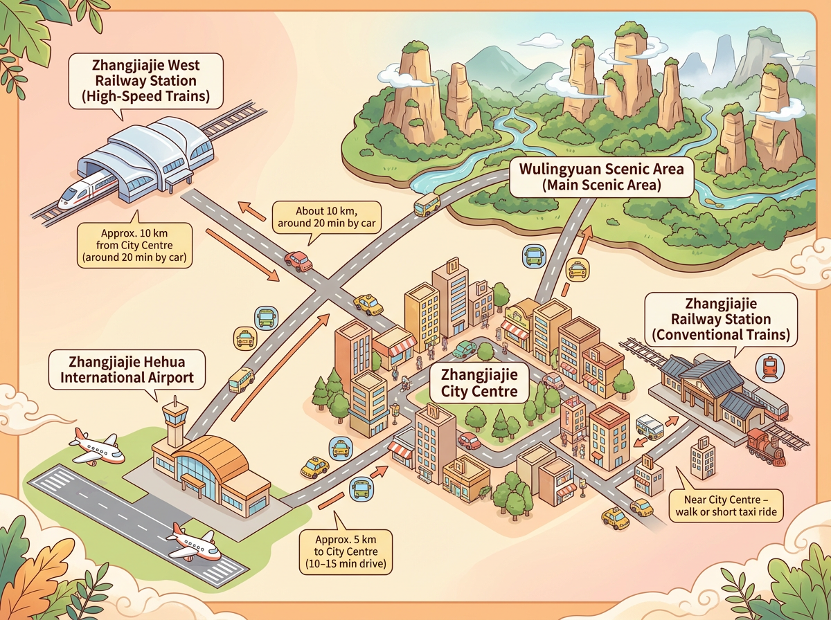
When you look closely at a Zhangjiajie city map, you’ll see that transport hubs, the city centre and the main scenic area are spread out rather than clustered together.
Zhangjiajie Hehua International Airport is located about 5 km from Zhangjiajie City Centre, roughly a 10-15 minute drive under normal traffic. The airport appears just south-west of the urban area. From the airport, taxis and airport buses connect directly to both the city centre and Wulingyuan.
Zhangjiajie has two main railway stations shown clearly on most Zhangjiajie maps.
Route | Estimated Travel Time | Notes |
|---|---|---|
Zhangjiajie Airport → Wulingyuan Scenic Area | ~60 minutes | Main gateway to the National Forest Park |
Zhangjiajie Airport → Zhangjiajie City Centre | ~10–15 minutes | Fast taxi or shuttle access |
Zhangjiajie City → Wulingyuan Entrance | ~40–50 minutes | Bus or private transfer |
Wulingyuan Town → National Forest Park East Gate | ~5–10 minutes | Usually by local shuttle or taxi |
Zhangjiajie City → Tianmen Mountain Cable Car Station | ~10–20 minutes | Easy urban transfer |
Wulingyuan → Tianzi Mountain Cable Car Base | ~15–25 minutes | Inside scenic area via shuttle buses |
Use our promo code to enjoy up to 5% OFF (up to S$3) on your attraction tickets, tours and eSIMs! Only for new users!
Buy Cheap eSIM Here
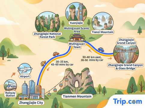
Tianmen Mountain is located right next to Zhangjiajie City, close to the airport and railway stations. The most famous sights, including Zhangjiajie National Forest Park, Yuanjiajie, and Tianzi Mountain, are all within the Wulingyuan Scenic Area, about 30–35 km north of the city (around 45–60 minutes by car). Wulingyuan Town sits beside the park entrances and is the best base for exploring these areas. The Zhangjiajie Grand Canyon and Glass Bridge lie further east of Wulingyuan, roughly 30-40 km away, and are usually visited as a separate half-day or full-day trip.
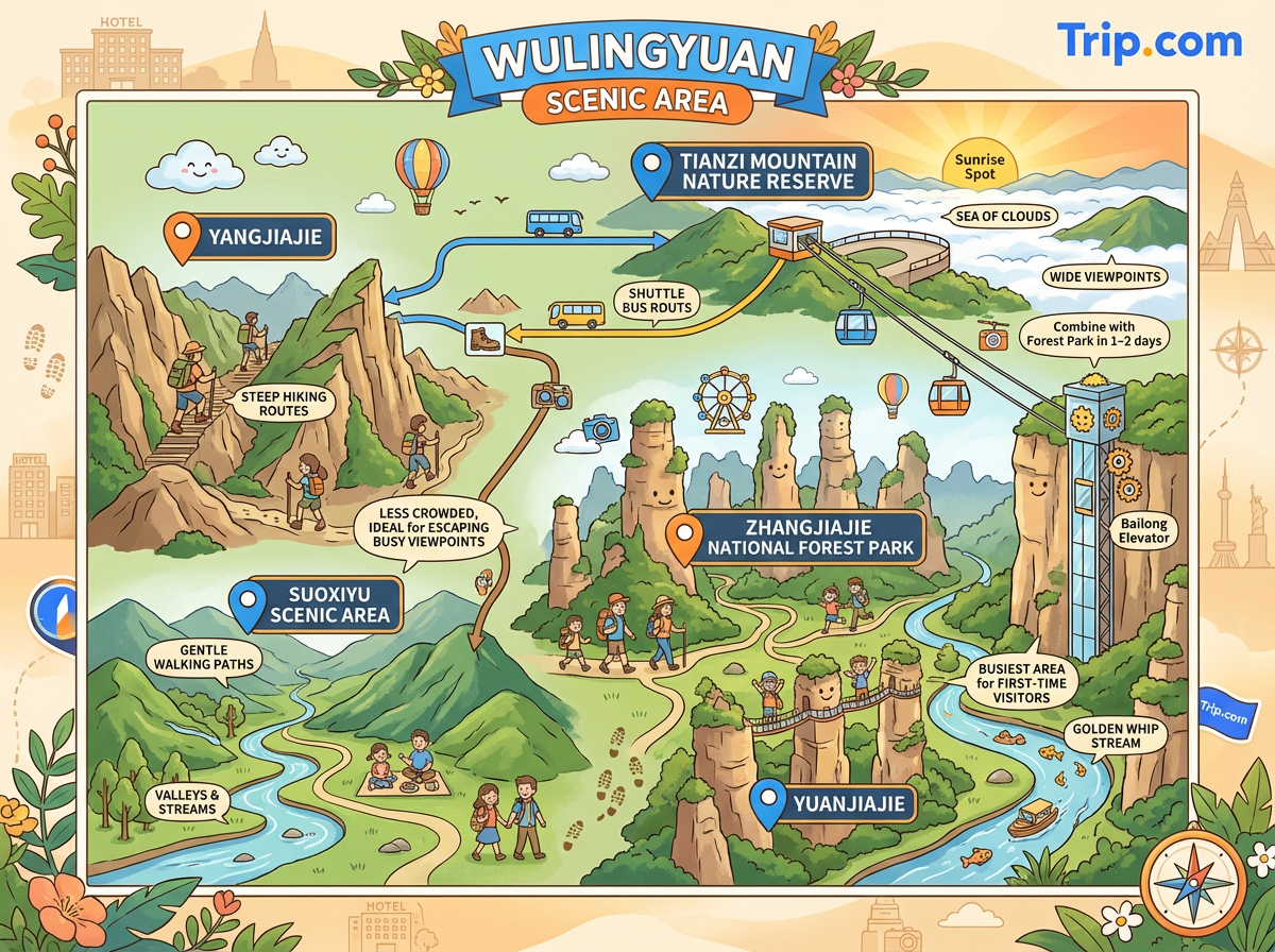
Rather than being one single park, Wulingyuan is a large protected area made up of several connected scenic zones, all linked by internal shuttle buses, hiking trails and cable cars.
At the heart of the map is Zhangjiajie National Forest Park, the most visited section and home to the iconic sandstone pillars that inspired the Avatar landscapes. This area includes highlights such as Yuanjiajie, Golden Whip Stream and the Bailong Elevator, and is where most first-time visitors spend the bulk of their time.
To the north of the forest park on the map, you’ll find Tianzi Mountain Nature Reserve, known for its wide viewpoints, sea-of-clouds scenery and sunrise spots. Tianzi Mountain is connected to the forest park by shuttle buses and a cable car, making it easy to combine both areas in one or two days.
On the western side of the Wulingyuan map lies Yangjiajie, a quieter area with steeper hiking routes and dramatic ridgelines. Nearby is Suoxiyu Scenic Area, which features valleys, streams and gentler walking paths. These two areas are less crowded and ideal if you want to escape the busiest viewpoints while still staying within the Wulingyuan Scenic Area.
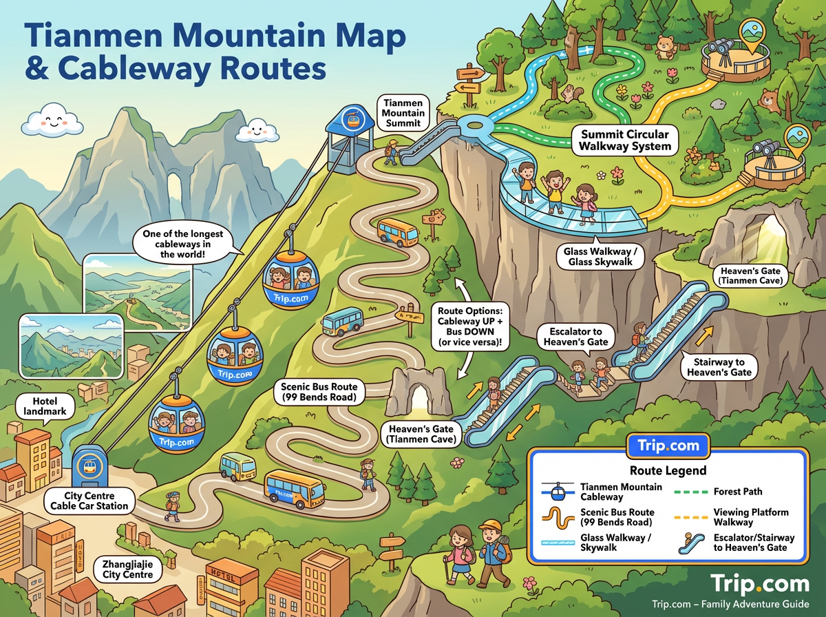
The mountain sits right next to Zhangjiajie City, and the map clearly shows two main ways to reach the summit: by cable car or by scenic bus.
The most famous route marked on the map is the Tianmen Mountain Cableway, which runs directly from the city centre up to the mountain top. It’s one of the longest cable cars in the world and offers sweeping views as you ascend.
The alternative route uses a scenic bus that climbs the mountain via the legendary 99-bend mountain road, stopping near Heaven’s Gate (Tianmen Cave) before continuing to the upper areas. On some ticket types, you’ll go up one way and come down the other, which the map helps clarify at a glance.
At the top, a circular walkway system links the cliff-edge glass walkways, forest paths and viewing platforms. When navigating these routes, follow the colour-coded paths on the map and allow time for queues at popular glass sections. Heaven’s Gate is marked as a separate area below the summit, accessed by a long escalator or stairway.
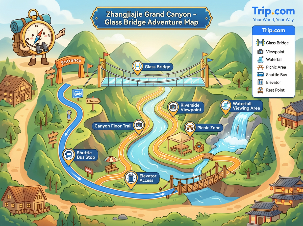
The Zhangjiajie Grand Canyon map shows the layout of one of the most thrilling attractions in the region, centred around the Glass Bridge.
From the entrance, paths lead visitors along well-marked trails that connect the canyon floor, riverside viewpoints, and the suspension bridge itself. The Glass Bridge spans the canyon, offering spectacular aerial views of the cliffs and river below.
Other notable features on the map include waterfall viewing areas on the side trails, picnic zones, and access points for shuttle buses or elevators.
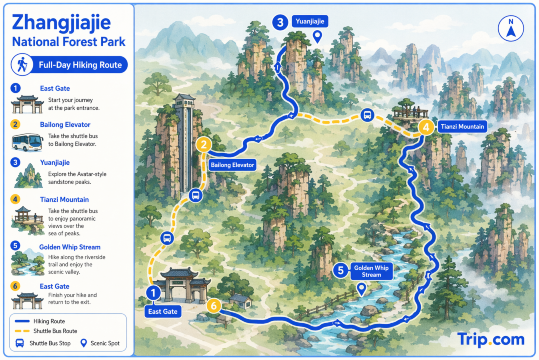
A practical full-day hiking route in Zhangjiajie National Forest Park starts at the East Gate and takes the shuttle bus up to the Bailong Elevator, then continues to Yuanjiajie to explore the Avatar-style sandstone peaks. From there, proceed by shuttle to Tianzi Mountain for panoramic viewpoints over the “sea of peaks”. In the afternoon, descend gradually and finish with a relaxed walk along the Golden Whip Stream, following the riverside trail back towards the exit. This route combines cable transport and hiking efficiently, covering the park’s most iconic landscapes without unnecessary backtracking.
Book Flights to Zhangjiajie
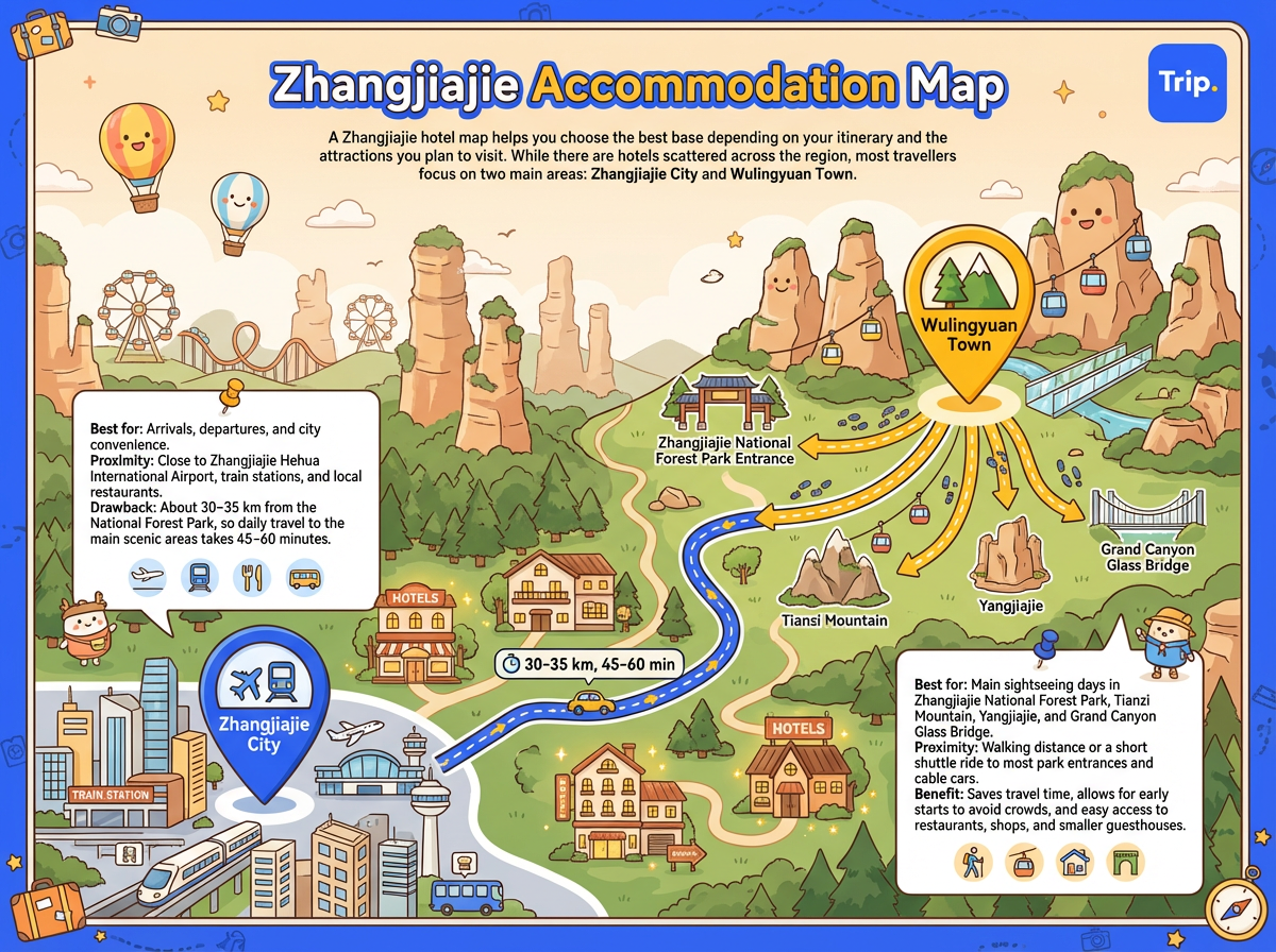
A Zhangjiajie hotel map helps you choose the best base depending on your itinerary and the attractions you plan to visit. While there are hotels scattered across the region, most travellers focus on two main areas: Zhangjiajie City and Wulingyuan Town.
Discover the world with Trip.com! Book the perfect hotel anywhere in the world and get an unbeatable 10% discount if you're a first-time user! Download our app now and start planning your next trip with ease.
Exploring Zhangjiajie without a map can be overwhelming, given how its attractions are spread across different towns and scenic areas. From Tianmen Mountain near the city to the towering peaks of Zhangjiajie National Forest Park and the thrilling Grand Canyon Glass Bridge, a good map helps you visualise distances, plan routes, and choose the best base for your stay.
 1478625 booked