LRT Map: The Ultimate Guide to Navigating Singapore LRT System

By ReddotExplorer
August 10, 2023
Whether you're a resident or a visitor, understanding the LRT map and LRT system can significantly enhance your travel experience in Singapore. This guide provides a comprehensive guide to the LRT lines, fares, ticketing systems, and key attractions at the lines.
Singapore LRT System Overview
Source: Wikipedia
Singapore's Light Rapid Transit (LRT) system is an essential part of the city-state's public transportation infrastructure. Serving as a feeder service to the main MRT lines, the LRT connects residential areas to key transport hubs. With over 40 stations across two LRT lines, the 28km system serves over 200 thousand daily riders.
The LRT system is designed to provide quick and convenient access to various parts of Singapore, especially in areas not directly served by the MRT.
It's an integral part of Singapore's commitment to sustainable urban mobility, reducing the reliance on private vehicles and enhancing the efficiency of public transportation
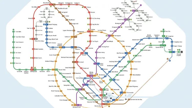
LRT Map
Source: LTA
The Singapore LRT system is designed to act as feeder services, bringing commuters closer to their homes and complementing the Mass Rapid Transit (MRT) lines that span the island.
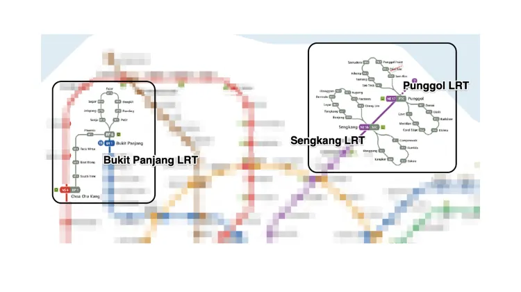
The LRT system connects to the MRT system at six interchanges: Bukit Panjang, Choa Chu Kang, Sengkang, Punggol, Ten Mile Junction, and Woodlands. This provides seamless travel across the public transport network.
The LRT system consists of three lines, covering a total distance of 28.8 km with over 40 stations.
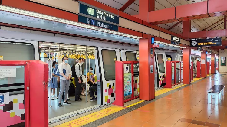
Bukit Panjang LRT (BPLRT)
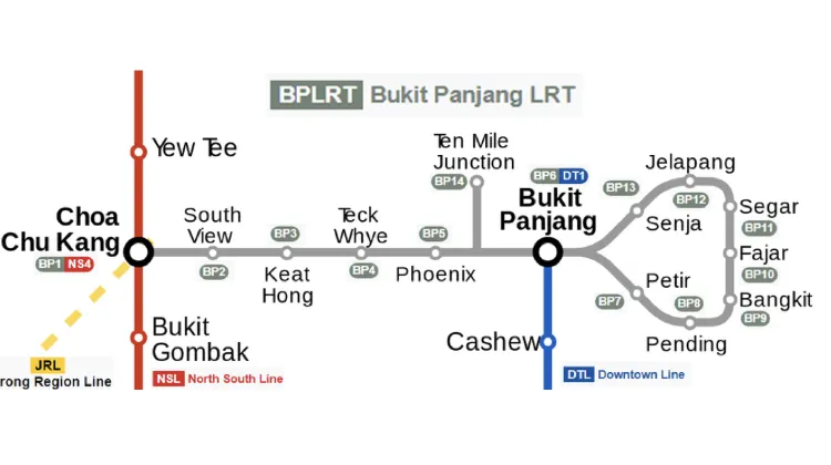
Source: Wikipedia
This line serves the Bukit Panjang area and is operated by SMRT Corporation Ltd (SMRT).
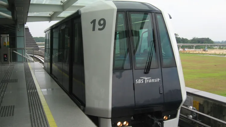
Sengkang LRT (SKLRT)
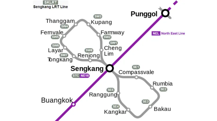
Source: sbstransit.com.sg
This line serves the Sengkang area and is operated by SBS Transit (SBST).
Punggol LRT (PGLRT)
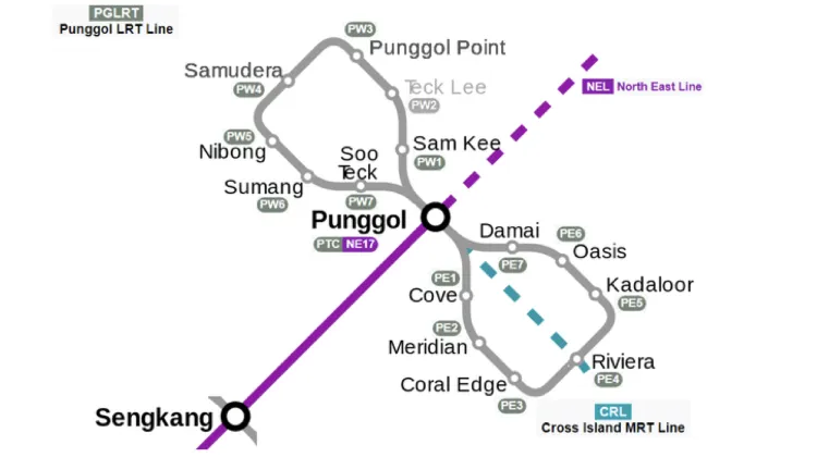
Source: sbstransit.com.sg
This line serves the Punggol area and is also operated by SBS Transit (SBST).
| Line | Loops | Stations | Interchanges |
| Bukit Panjang LRT (BPLRT) | 2 | 14 | Bukit Panjang, Choa Chu Kang, Ten Mile Junction |
| Sengkang LRT (SKLRT) | 2 | 14 | Sengkang |
| Punggol LRT (PGLRT) | 2 | 15 | Punggol |
LRT Fares And Tickets
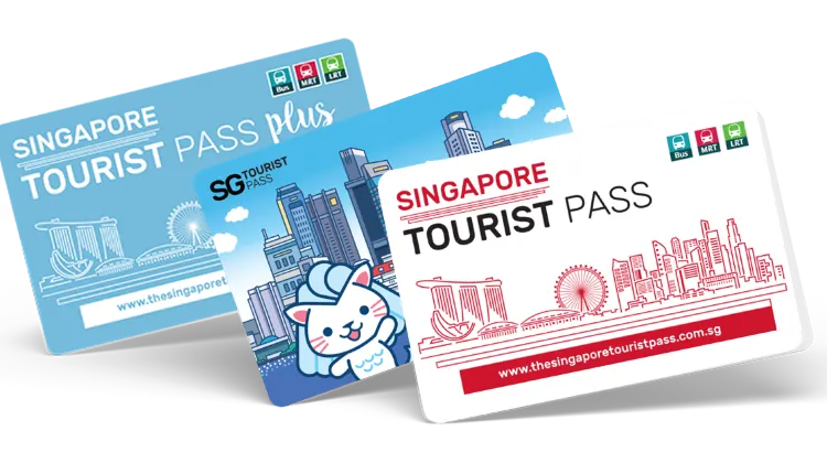
Source: ezlink.com.sg
LRT fares in Singapore are calculated based on the distance traveled, similar to the MRT system. Various payment methods and fare options are available to cater to different commuter needs.
Here's a table summarizing the key fare and ticketing options:
| Payment Method | Description | Suitable For | Fare |
| EZ Link Card | A contactless payment card that can be topped up. Used for multiple rides. | Regular Commuters | SGD $0.77 to $1.67 (Adults) |
| NETS FlashPay Card | Similar to EZ Link, a contactless payment card used across public transport. | Regular Commuters | Similar to EZ Link |
| Single Trip Ticket | A ticket purchased for a single ride. Can be bought at ticketing machines. | Occasional Riders, Tourists | SGD $1.40 to $2.30 |
| Concession Cards | Discounted fare cards for senior citizens, students, and persons with disabilities. | Eligible Individuals | SGD $0.38 to $0.83 |
Understanding the different fare options and payment methods ensures a smooth and convenient travel experience on Singapore's LRT system. Whether you're a daily commuter, an occasional rider, or a visitor exploring the city, there's a suitable option tailored to your needs.
There is an option of Tourist Pass for unlimited travel on public transport for a fixed period (1, 2, or 3 days).
LRT Operation Hours And Frequency
Source: Wikipedia
The LRT system generally operates from 5:30 am to 12:30 am daily. Note that different LRT lines may differ slightly.
The frequency of the trains varies from 3 to 10 minutes depending on the time of day and line.
Here is a table that shows the approximate frequency of the trains for each LRT line:
| Line | Peak Hours (7:00 AM to 9:00 AM and 5:00 PM to 7:30 PM) | Off-Peak Hours | Night Hours |
| Bukit Panjang LRT (BPLRT) | 3-4 min | 4-5 min | 5-8 min |
| Sengkang LRT (SKLRT) | 3-4 min | 4-5 min | 5-8 min |
| Punggol LRT (PGLRT) | 3-4 min | 4-5 min | 5-8 min |
You can also check the exact arrival time of the next train at any station using the Passenger Information Display System (PIDS) or the mobile app MyTransport.SG.
FAQs: LRT Map
-
How much does it cost to travel on the LRT line?
-
Can I bring my luggage or bicycle on the LRT train?
-
What are the operating hours of the LRT system?
-
What if I encounter a problem or emergency while using the LRT?
LRT Map Conclusion
The Singapore LRT map is a great tool to help you discover and enjoy the best of Singapore. It is easy to use, affordable, and convenient. It also connects you to the MRT system, which gives you access to even more destinations and attractions in Singapore.
With the Singapore LRT Map, you can experience the different facets of Singapore, from its nature and culture to its modernity and diversity. You can also find something that suits your taste and budget, whether you are looking for adventure, relaxation, or entertainment.
So what are you waiting for? Grab your ticket or card, hop on the train, and start your journey with the Singapore LRT Map!
Find Cheap Deals & Discover Destinations
-
Featured guides
-
Trip.com links
- train to kl from singapore
- Shanghai Metro
- China Power Bank Limit
- mdac malaysia
- Renew Autopass Singapore
- Vietnam Arrival Card
- Trip.com Customer Service
- Batam Arrival Card
- China Entry Requirements
- Busan Metro
- Singapore Public Holiday 2027
- Touch n Go App
- Anywheel Singapore
- universal studios singapore tickets
- Buy Now Pay Later
- Frankfurt Airport to City
- Osaka Station to Kyoto Station
- Bangkok to Pattaya
- Trip.com Promotion Codes
- Trip.com Flight Deals
- Trip.com Credit Card Promotions
- How to Book Cheap Hotels
- How to Book Cheap Flights
- Trip.com Member Rewards
- Trip Weekly Hotel Sales
- Online Hotel Booking
- Online Flight Booking
- Trip.com Travel Guide
- Book China Train Tickets
- Trip.com Seat Selection
- Singapore Public Holidays 2027
- Trip.com 优惠码
- Trip.com Travel Guides
- Trip.com 7.7 Mega Sale