[Newest] This month's promo code pack
OverviewBookNearbyReviewsWin PrizesRecommended
Share to
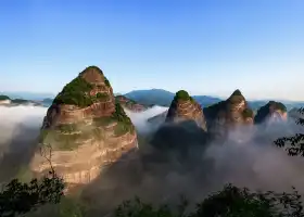
Ziyuan Danxia Guojia Dizhi Park
資源丹霞國家地質公園5.9
11 Reviews
Recommended sightseeing time:2-4 hours
Address:
Zijiang Danxia Tourist Wharf, Zijiang Scenic Area, Guilin, Ziyuan County, Guilin CityMap
What travelers say:
Danxia landform people are particularly loved by travelers. Especially the Danxia landform in the northwest attracts many people. There are also several famous Danxia landforms in the south. The Bajiaozhai of your total resources is one of them. Very beautiful Danxia landforms.
MoreSaved by 1
Ziyuan Danxia Guojia Dizhi Park Highlights: Must-See Features and Attractions
Some information may have been translated by Google Translate
Resource Danxia National Geopark starts from Resource County in the south and borders Xinning County in Hunan Province in the north and northwest. It is 33 kilometers long from north to south, distributed along the Zijiang River and both sides of the Zijiang River from east to west, with a width of 3-9.6 kilometers and a total area of 125 square kilometers. The geopark is characterized by the Danxia landform, and the geomorphological landscape of the park has the characteristics of "majestic, strange, dangerous, secluded, beautiful and auspicious". The Cretaceous strata formed between 135 and 65 million years ago are monoclinic, and the mountain generally develops steep cliffs due to the action of flowing water and collapse, and the foot of the slope accepts accumulation to form a gentle slope, thus creating the "top of the Danxia landform". The basic characteristics of sloping, steep body and gentle footing". Resources Danxia landform has many deep lane valleys and barrier valley landforms, such as the east and west line of Tianmen scenic spot, the life and death valley and Huangsha River narrow valley in Bajiaozhai scenic spot, especially the narrow valley and barrier valley. It is like entering a labyrinth, with high, steep and peculiar stone walls on both sides, exotic flowers and plants in the valley, gurgling water, and no one in a hundred miles. Show, with agility, a sense of returning to simplicity. Resources The main peak of the Xinning Red Layer Basin, Bajiaozhai, is a square mountain-shaped landform with an altitude of 814 meters and a relative height of about 400 meters. There are smooth and tangible cliffs on the east, west and north sides. a feeling of. In addition, there are many magnificent geological and landform scenic spots in the resource Danxia landform, such as Tianji, Longji, Fengfan Rock, and the remains of the Zixin Great Fault. There are rich shapes, such as snails, elephants, big Buddhas, goats, camels, owls, penguins, sails, honeycombs and various mural patterns of elephants, etc. Among them, the peculiar types are "group snails watching the sky", "tear man stone". ", "Renzi Tian" stone, "Fanfan stone", "Idol drinking water", "Shanzi stone", "Jiang Jun riding murals" and so on.
Recommendations Near Ziyuan Danxia Guojia Dizhi Park
Ziyuan Danxia Guojia Dizhi Park Reviews: Insider Insights and Visitor Experiences
Some reviews may have been translated by Google TranslateWrite a Review
/5
Outstanding ReviewsAll (11)
Latest
With Photos (5)
Positive Reviews (9)
- 1
- 2
- 3
You Might Also Like
Ghuilin Danxia Bajiaozhai Scenic Area
5.9
4.5/5419 Reviews
Save S$ 6.39
From S$ 19.54
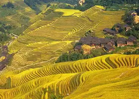
Longji Rice Terrace
8.3
4.5/54949 Reviews
From S$ 15.03

Lijiangyuan Grand Canyon
5.2
4.7/5178 Reviews
From S$ 9.40
Lingqu
5.3
4.4/5566 Reviews
From S$ 8.46
Nearby Attractions
Ghuilin Danxia Bajiaozhai Scenic Area | Wupaihe Drifting | Guilin Maoer Mountain | Zijiang Drift Scenic Area | Ziyuan Tianmen Mountain | 古木沖景區 | Lijiangyuan Grand Canyon | Laoshanjie Virgin Forest | Shelter Bridge | Baoding Pubu | 象鼻山 | Observation Deck, Bajiaozhai Scenic Area | 貓兒山露營地 | Liyuan Waterfall Sceneic Area | Zhenbaoding Mountain | Aisle | 石山底龍洞峽景區 | 資源小九寨溝景區 | 里山森活 | Guilinmao'er Mountain Ecological Park | Bamboo Sea Terraces | Shiwan Gutian | 資江漂流景區 | 越城嶺
Popular Types of Attractions in Ziyuan
Nature | Mountains | Forests | Caves | Architecture & Landmarks | Historical Architectures | Squares | Featured Neighborhoods | Historic Sites | Historical Sites | Ancient Villages | Ancient Towns | Religious Sites | Memorial Temples | Temples | Churches and Cathedrals | Traditional/Cultural Experiences | Villages | Farms | Traditional Experiences | Exhibition Centers | Museums | Memorial Halls | Fine Art Galleries | Lifestyle | Resorts | Libraries | Campgrounds | Parks | City Parks
Popular Restaurants in Ziyuan
怡然农庄 | 绝味鸭脖(镇中路店) | 世外桃源摄影之家餐馆 | 小食候湘(桂林资源一店) | 厦门西饼 | BA JIAO ZHAI XI YUE NONG GU LE | 大沙洲休闲农庄 | SI JI WU NONG GU CAI GUAN | 辣库(资源店) | 十大碗柴火饭店 | 婵娟(资源中学店) | 山居人家(城中店) | 苗家山寨 | 毛家饭店(丹霞路店) | 书亦烧仙草(资源县地王大厦店) | 八角寨旅游餐馆 | 幸福心语(西延南路店) | 美味基(资源店) | 首尔·韩式炸鸡(资源店) | 南瓜烧烤 | 包子铺 | 527亿烧烤 | 西西烘焙 | 朋友圈柴火饭庄 | 益禾堂(地王店) | 12楼优选咖啡(资源店) | 有一家烤肉饭 | 老王家农庄 | 每刻(资中小区店) | 苗家餐馆、住宿
Popular Destinations
Dubai Travel | New Taipei City Travel | Guizhou Travel | Kaifeng Travel | Nanning Travel | Chaozhou Travel | Hoi An Travel | Taichung Travel | Davao Travel | Kanazawa Travel | Sokcho-si Travel | Sentosa Island Travel | Lake Biwa Travel | Sorrento Travel | Shandong Travel | Thiruvananthapuram Travel | Oceania Travel | El Paso County Travel | Waldbillig Travel | Semarang Travel | Washington County Travel | Lake County Travel | Tarras Travel | Oberhavel Travel | Vercelli Travel | Delft Travel
Recommended Attractions at Popular Destinations
Bangkok attraction near me | Tokyo attraction near me | Manila attraction near me | Hong Kong attraction near me | Taipei attraction near me | Seoul attraction near me | Los Angeles attraction near me | New York attraction near me | Shanghai attraction near me | Kuala Lumpur attraction near me | Shenzhen attraction near me | Osaka attraction near me | Singapore attraction near me | London attraction near me | Guangzhou attraction near me | San Francisco attraction near me | Beijing attraction near me | Macau attraction near me | Bali attraction near me | Paris attraction near me | Ho Chi Minh City attraction near me | Orlando attraction near me | Jakarta attraction near me | Chicago attraction near me | Phuket attraction near me | Toronto attraction near me | Istanbul attraction near me | Dallas attraction near me | Cebu attraction near me | Seattle attraction near me
Popular Trip Moments
Guilin's landscape tops those elsewhere, and Langshan's scenery rivals that of Guilin | Bajiaozhai in winter | It's snow season again! Come to this place in Guilin to see the beautiful snow scene | The people of Guilin are overjoyed: "My city is snowing" | Guilin Bajiaozhai|If the mountain does not come to me, I will go to the mountain | Annual inventory of hiking routes that everyone wants to challenge | Guangxi Zhenbaoding | "One of the most beautiful Danxia landscapes in China" | Located in the northern part of Ziyuan County, Guilin City, Guangxi | I hope more people will know about the beauty of this small county town
More Things To Do in Ziyuan
Guilin Private Day Tour to Ziyuan Bajiaozhai Geography Park with the Lunch | Guilin Private Tour: To Badjiao National Forest Park | China eSIM Day Pass/data Package days selected without cards QR code | China·Hong Kong·Macau eSIM|Unlimited 4G High-speed Data | China Mainland eSIM|China Mobile Unlimited 4G High Speed Data | China, Hong Kong, and Macau eSIM|Total 5GB/10GB/15GB/20GB High-speed 4G LTE Unlimited high-speed data | Mainland China eSIM |China Mobile 4G high-speed unlimited data eSIM | Asia・Australia eSIM|AIS SIM2Fly 8 days 6GB High-speed Unlimited 5G/4G Data | [China Mainland] eSIM | SIM to China | 8GB 8days 4G high speed | Mainland China + Hong Kong + Macau eSIM 4G Data Daily Plan QR Code | Trip.SIM Japan, South Korea, Macau, Taiwan and many places in Asia + Australia and New Zealand 4G travel data roaming phone network card 4 days/7 days | eSender - Mainland China eSIM daily package/traffic package, days optional. No need to get the card QR code | [China, Hong Kong and Macau] 4G network | Unlimited traffic | Self-pickup at the airport | WiFi rental, high-speed traffic, shared by multiple people, ready to use at startup, 12H standby, 24H customer service | Global multi-region A series eSIM|High-speed data, travel and business Internet access, optional unlimited data, optional days, QR code | Mainland China + Hong Kong + Macau eSIM Data Plan QR Code | 5-Day Private Tour from Guilin to Xiamen | 6-Day Private Tour from Lijiang to Guilin | Private Guilin Half Day Tour: Fubo Mountain, Reed Flute Cave and Elephant Hill | 3-Day Private Tour from Beijing by Air: Guilin, Longji Rice Terrace and Yangshuo | Longji Rice Terraces Day Tour from Guilin hotel | Yangshuo Private day Tour of Longji Rice Terraces & Sanjiang Chengyang Dong village | Global eSim for 140+ countries (sent via email) by Xplori | AIS Asia esim data package (QR code) | Private Guilin Half-Day Tour: Fubo Mountain, Reed Flute Rock, and Elephant Trunk Mountain | Guilin Private day Tour of Longji Terrace and Dazhai Village | AIS SIM2Fly Global eSIM|15 days 6GB high-speed 4G/5G Unlimited Data | [FLASH SALE] China, Hong Kong, Macau eSIM - Data plan by Gohub (QR Code) | 5-Days Guilin tour with the Yangshuo and overnight in Longji Rice Terraces | Global multi-region C series eSIM|Common in 84 countries Travel and business Internet access Optional unlimited data Optional days QR code | 8-Day Private Tour from Nanning to Guilin
Payment Methods
Our Partners
Copyright © 2024 Trip.com Travel Singapore Pte. Ltd. All rights reserved
Site Operator: Trip.com Travel Singapore Pte. Ltd. Travel License No. 02943
Site Operator: Trip.com Travel Singapore Pte. Ltd. Travel License No. 02943
Danxia landform people are particularly loved by travelers. Especially the Danxia landform in the northwest attracts many people. There are also several famous Danxia landforms in the south. The Bajiaozhai of your total resources is one of them. Very beautiful Danxia landforms.
The landscape of the interior of the park has the characteristics of "xiong, Qi, Risk, Settle, Xiu, Ao". The main peak of Xinning Red Basin, Bajiaozhai, is a square mountain-shaped landform, 814 meters above sea level, about 400 meters relative height, the east, west and north three sides are smooth and tangible cliffs, there is a feeling of horizontal air after climbing the top of the mountain.
In fact, this is a scenic spot connected to the Lushan Mountain in Hunan, all of which are similar to Danxia landforms, which is equivalent to the two provinces managing half of the mountains and forests at the same time. Hunan buys tickets to go up the mountain and can go down the mountain from Guangxi.
The strange, dangerous and beautiful cliffs, peaks and forest pillars, and the colorful colors of Xinjiang's colorful cities are integrated. Its majesty, spectacular scene, strange shape, and colorful are amazing
Mainly the Bajiaozhai Scenic Area, and there is Tianmen Mountain. Their Danxia is very beautiful, definitely ranked among the top in the country, but the development is not good, the traffic is inconvenient, and there are not many people to go.