[Newest] This month's promo code pack
OverviewBookNearbyReviewsWin Prizes
Share to
Horton Plains National Park
5.8
167 Reviews
 based on 1088 reviews
Open Opens at 6:00-16:00
Recommended sightseeing time:3-5 hours
Address:
No 23/A Dayagama east rd, Dayagama, Sri LankaMap
Phone+94 112 426 900
What travelers say:
@🇱🇰 Sri Lanka, Nuwara Eliya Novara Eliya Horton Plain National Park Horton Plains National Park During British colonialism, it was named after Wilmert Horton, the British Governor in Ceylon (now known as Sri Lanka), (also said to be his wife Anne • Horton). In 1969, it was designated a wildlife refuge. In July 2010, due to its biodiversity, the central highlands of Sri Lanka (including the Horton Plain National Park, the Peak Wilderness Reserve where Adam Peak is located and the Knuckles Mountains) were listed on the World Heritage List ~50+ local geoguide full-time control speed (counterclockwise hiking), The "Horton Three-person Team" with the two beautiful young ladies opens 10km 4h special soldier mode 4:00 get up ➡️4:45 depart the hotel➡️6:00 sun rise➡️ 6:30 hiking ➡️no stop walking➡️10:30 leave the park➡️11:20 arrive the hotel➡️11:45 travel move🤣 Overall feeling, it is easy to go up the mountain and difficult to go down the mountain ps: In order to protect the environment, the food will be required to unpack the plastic bag and put it in the paper bag provided by the garden. The washing room [laughing] at the entrance is a thousand miles away. There is a toilet. It is not a dry toilet. In addition, it seems that there are only two bathrooms in the park, and the walk from the exit is about 1 hour.
More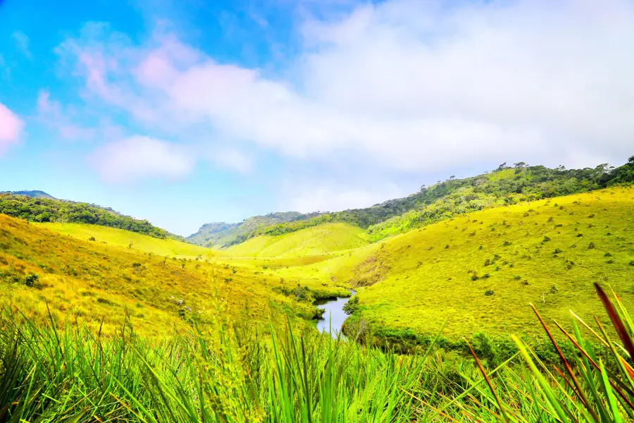
See all 52 photos
Saved by 15
Horton Plains National Park Highlights: Must-See Features and Attractions
Some information may have been translated by Google Translate
Horton Plains National Park is an important natural heritage of Sri Lanka and a national park that allows tourists to hike. The "plain" itself is a plateau about 2,000 meters above sea level, covered with virgin grasslands and dotted with several dense forests. 1. Scenic History Horton Plains was formerly known as MahaEliyaThena, which means "Great Plains". During the British colonial period, it was named after the British governor of Ceylon, Wilmert Houghton (also said to be his wife, Anne Houghton). It was not until 1969 that the Houghton Plain was designated as a wildlife reserve. Because of the biodiversity of Horton Plains, it was planned as a national park for tourists to visit in 1988. In July 2010, Sri Lanka's central highlands, including Horton Plains National Park, the summit wilderness reserve where Adam's Peak is located, and the Knuckles Mountains were inscribed on the World Heritage List. 2. Scenic features Horton Plains, if literally translated, are actually "Horton Plains", from which we can intuitively feel Horton's topographical features - flat and open, but not static. The weather on the plateau is unpredictable and Horton is notoriously windy. Hiking on the wide slopes of the Horton Plain, there are ups and downs along the way. In front of you are vast hills, small rivers and various tropical plants, and the blue sky and fresh air are more enjoyable. In addition to the attractive World's End cliffs, you can also see a variety of wildlife such as monkeys, elk and various birds while hiking in the Horton Plains National Park. The entire scenic spot is very primitive, please do not go to areas outside the prescribed route when hiking to avoid danger. On the way back you will pass Baker's Falls, which is not spectacular but adds to the fun of your hike. 3. The trekking route to Horton Plains National Park generally requires a chartered car. After arriving at the gate and purchasing the ticket, you can drive in for a while, and then start the hiking tour from the parking lot. There is a circular hiking route in the national park, with a total length of about 9.5 kilometers. Tourists can only walk within the specified range according to the road signs (it is strongly recommended to walk in a clockwise direction). It takes about 3-4 hours to walk the whole way. Walk from the entrance to the end of the world for about 4 kilometers, then walk 2 kilometers to a Baker Falls, and then walk 3.5 kilometers back to the entrance. 4. Wildlife Due to its location at the turning point of many rivers, the Horton Plain has very rich wildlife species, often leopards, deer and wild boars. Lanka's local "Purple-faced Vervet Monkeys" sometimes flicker through the forest along Ohiya Road, and sometimes peek in the woods near the end of the world. This area is also great for bird watching. Native Yellow-eared Nightingale, Fantail Warbler, Grey-headed Thrush, Lankan White-Eyed, Lankan Thrush, Lankan White-eyed Arrenga, Lankan Blue Magpie, Mountain Eagle, etc. 5. Natural Plants There is a grass called Chrysopogon that covers the grasslands on the plateau, while the swamp is a breeding ground for the rich species of Sphagnum. The white-flowered delphinium is the dominant vegetation in mountain forest areas. Dwarf trees and shrubs are joined by mosses and lichens. There is also Rhododendronzelanicum, which produces blood-red flowers. Strobilanthes with sharp leaves bloom every five years.
Recommendations Near Horton Plains National Park
Horton Plains National Park Reviews: Insider Insights and Visitor Experiences
Some reviews may have been translated by Google TranslateWrite a Review
 (167 Reviews)Trip.com
 (1,088 Reviews)TripAdvisor
/5
Outstanding ReviewsAll (167)
Latest
With Photos (111)
Positive Reviews (157)
Negative Reviews (1)
- 1
- 2
- 3
- 4
- 34
Nearby Attractions
Nuwara Eliya Post Office | New Zealand Farm | Lake Gregory | Ravana Ella Falls | Labookellie Tea Lounge | Great World's End Drop | Hakgala Botanical Garden | Damro Tea main Board | Victoria Randenigala Rantembe Sanctuary | Seetha Amman Kovil | Ramboda Falls | Moon Plains | St. Clair Viewing Gallery | Ambewela Farm | Victoria Park of Nuwara Eliya | Mlesna Tea Castle St Clair | Nanu Oya Railway Station | Damro Labookellie Tea Centre and Tea Garden | Bluefield Tea Gardens | Race Course Ground NUWARA ELIYA | Piduruthalagala Conservation Forest | Shri Bhakta Hanuman Kovil | Nuwara Eliya Golf Club | Pidurutalagala | Baker's Falls | Kadiyanlena Eco Resort | Gallway's Land National Park | Devon Falls | Bomburu Ella Waterfall | Dunsinane Falls
Popular Types of Attractions in Nuwara Eliya
Popular Spots | Religious Sites | Churches and Cathedrals | Temples | Other Places of Worship | Parks | City Parks | Zoos | Aquariums | Architecture & Landmarks | Gardens | Monuments | landmark | Nature | Nature Reserves | Lakes | Beaches | Outdoor Sports | Hiking | Water Sports | Hiking/Biking | Historic Sites | Historical Sites | UNESCO World Heritage - Cultural Sites | Castles | Exhibition Centers | Museums | Art Museums | Military Sites | Lifestyle
Popular Restaurants in Nuwara Eliya
Grand Thai | Salmiya | Edinburgh TEA TRAIN | Milano Restaurant | Huayuan Chinese Restaurant | Tea Lounge by The Grand Hotel Nuwara Eliya | Indian Summer Nuwara Eliya | Barnes Hall | Genuine Humbugs Restaurant & Inn | Old Course Restaurant | Victoria Gardens Restaurant | Mackwoods Tea | Silvas Restaurant | Coffee Bar | Tea Hills Restaurant | Hill Club Restaurant | sinha Restaurant | Araliya Food Court | Tea Factory Hotel Restaurant | Grashia Restaurant | BlueField Tea Restaurant | Palladium Restaurant | Sambar | Restaurant Two | Tea Bush Ramboda | Remarko | Road Hole Bar | Lake View Pub | Thaj Hotel & Bakers | Humbug Restaurant
Popular Destinations
Hakone Travel | Wakayama Prefecture Travel | Chitose Travel | Yanji Travel | Fukuoka Travel | Phillip Island Travel | Siguniang Mountain Travel | Phu Quoc Island Travel | Hanoi Travel | Keelung Travel | Mohe Travel | Queenstown Travel | Grindelwald Travel | Tashkurgan Travel | Athens Travel | Bratislava Travel | Mumbai Travel | Pahang Travel | Chiba Prefecture Travel | Denver Travel | Side Travel | Spata Loutsa Travel | John O'Groats Travel | Saint-Jean-de-l'Ile-d'Orleans Travel | Minnehaha County Travel | Danville Travel | Portree Travel | District of Columbia Travel
Recommended Attractions at Popular Destinations
Bangkok attraction near me | Manila attraction near me | Tokyo attraction near me | Taipei attraction near me | Hong Kong attraction near me | Seoul attraction near me | Los Angeles attraction near me | Kuala Lumpur attraction near me | Shanghai attraction near me | New York attraction near me | Shenzhen attraction near me | Osaka attraction near me | London attraction near me | Singapore attraction near me | Guangzhou attraction near me | San Francisco attraction near me | Beijing attraction near me | Macau attraction near me | Bali attraction near me | Paris attraction near me | Jakarta attraction near me | Ho Chi Minh City attraction near me | Orlando attraction near me | Phuket attraction near me | Toronto attraction near me | Chicago attraction near me | Cebu attraction near me | Seattle attraction near me | Istanbul attraction near me | Fukuoka attraction near me
Popular Ranked Lists
Popular Family-friendly Attractions Near Biyang | Popular Premium Hotels Near Baishan | Popular Luxury Hotels Near Centre County | Popular Family-friendly Attractions Near Luodian | Top 20 Local Restaurants in Lhasa | Top 10 Local Restaurants in Copenhagen | Popular Family-friendly Attractions Near Manzhouli | Top 19 Local Restaurants in Los Angeles | Popular Luxury Hotels Near Rab | Top 10 Local Restaurants in Nairobi | Popular Family-friendly Attractions Near Daguan | Top 10 Local Restaurants in Geneva | Top 23 Local Restaurants in Macau | Top 19 Local Restaurants in Shenyang | Top 20 Local Restaurants in Lisbon | Popular Luxury Hotels Near Ancenis | Popular Luxury Hotels Near Changyang | Top 16 Local Restaurants in Edinburgh | Popular Family-friendly Attractions Near Aohan Banner | Popular Premium Hotels in Golmud | Popular Family-friendly Attractions Near Ergun | Popular Family-friendly Attractions Near Yonghe | Popular Family-friendly Attractions Near Huayuan | Popular Family-friendly Attractions Near Mizhi | Top 3 Luxury Hotels in Khao Yai | Popular Family-friendly Attractions Near Zichang | Top 21 Local Restaurants in Florence | Top 20 Local Restaurants in Las Vegas | Popular Family-friendly Attractions Near Old Barag Banner
Popular Trip Moments
🌄🛏️ Nuwara Eliya's Golden Ridge: A Cozy Retreat 🍃 | 🌿✨ Sri Lanka's Enchanting Heritance Tea Factory Stay 🏨🍃 | 🌟 Nuwara Eliya's Luxe Stay: Westbury Palace 🏰✨ | 🌱🍵 Serenity in Sri Lanka: Ceylon Tea Trails Escape 🍵🌱 | Sri Lanka, island circuit tour, whale watching at sea | 🌟 Nuwara Eliya's Hidden Gem: Bellwood Manor 🌟 | Summer retreat, highland pastures | Pines jungle | Beauty of Nuwaraeliya | Lake Gregory | 🇱🇰 Authentic local food in Nuwara Eliya | New Zealand Ranch | Full of holiday vibes! Life and money should be wasted on such places | Journey to Sri Lanka ~ Nuwara Eliya | ‘Little England ‘ Sri Lanka | Mackwood Tea Factory
Sri Lanka | The Grand view of the Grand Hotel 😍 | 🇱🇰 The best High Tea @ The Grand Hotel Nuwara Eliya | 🇱🇰 Tea Factory Tour @ Damro Labookellie Tea Lounge | Boat Paddling on beautiful Lake Gregory 🇱🇰 | Stay in Kent Cottage, a colonial style bungalow 🇱🇰 | 8-day trip to explore Sri Lanka, classic travel tips and off-the-beaten-path experiences fully revealed! | Nuwaraeliya | Selected as a British colonial-style tea garden hotel by L'été Indien. 🛖 | Marabedda Garden Resort, Rikillagaskada 🍃 | Tea Plantations at Nuwara Eliya | Sri Lanka
Popular Travel Types
More Things To Do in Nuwara Eliya
Trekking in Illukpelessa Village from Ella | Meditation & Music Therapy at Polgahaamuna Waterfall | Ohiya City to Colombo Airport (CMB) Private Transfer | Ella Hotel to Kandy Hotel Transfers | Day tour to Nuwareeliya (Little England) from Kandy | Day Excursions to Horton Plains & Local Train Experience from Ella | Kandy To Nuwaraeliya Scenic Train Ride and Nuwaraeliya City Tour And Drop Ella | Ella Hotel to Arugam Bay Hotel Transfers | Nuwara Eliya City to Bandarawela City Private Transfer | Guided Hike to Single Tree Hills from Nuwara Eliya | Nuwara Eliya City to Negombo City Private Transfer | Car/Van hire from Ella to Arugambay | Sri Lankan yoga for your Body and Mind with Our Sri Lankan yoga trainers. | Special Tourists Train Ride in Ella - Calypso Train | Reserved Train Seats from Ella to Colombo | 6-Day Central Highlands UNESCO World Heritage Adventure Tour | Lipton's Seat Tea Factory Visit Tea Plantation Tour | From Ella | 3-Day Hill country tour of Sri Lanka | Private 6-Day-Highlights-Tour Around Sri Lanka | Sri Lanka Horton Plains National Park + Pedro Tea House + Pink Post Office One-Day Tour [Round trip to Kandy | National Park Hiking, Tea Factory Picking | Full Chartered Itinerary Adjustable] | Highlights Of Sri Lanka | 5 Nights 6 Days | Kandapola City to Colombo Airport (CMB) Private Transfer | Highlights Of Sri Lanka- 7 Days Tour | 1 Day Tour of Ella From Kandy | Private Nuwara Eliya Day Tour from Kandy with Pick up | Nuwara Eliya City to Avissawella City Private Transfer | Private 3-Day-Highlights-Tour Around Sri Lanka | Lipton's Seat and Dambatenna Tea Factory From Haputale - Day Tour | Sri Lanka Halal (Islamic) Tour (6 Days) | Train Seat Reservation from Ella to NuwaraEliya (Nanuoya)
Payment Methods
Our Partners
Copyright © 2024 Trip.com Travel Singapore Pte. Ltd. All rights reserved
Site Operator: Trip.com Travel Singapore Pte. Ltd. Travel License No. 02943
Site Operator: Trip.com Travel Singapore Pte. Ltd. Travel License No. 02943
@🇱🇰 Sri Lanka, Nuwara Eliya Novara Eliya Horton Plain National Park Horton Plains National Park During British colonialism, it was named after Wilmert Horton, the British Governor in Ceylon (now known as Sri Lanka), (also said to be his wife Anne • Horton). In 1969, it was designated a wildlife refuge. In July 2010, due to its biodiversity, the central highlands of Sri Lanka (including the Horton Plain National Park, the Peak Wilderness Reserve where Adam Peak is located and the Knuckles Mountains) were listed on the World Heritage List ~50+ local geoguide full-time control speed (counterclockwise hiking), The "Horton Three-person Team" with the two beautiful young ladies opens 10km 4h special soldier mode 4:00 get up ➡️4:45 depart the hotel➡️6:00 sun rise➡️ 6:30 hiking ➡️no stop walking➡️10:30 leave the park➡️11:20 arrive the hotel➡️11:45 travel move🤣 Overall feeling, it is easy to go up the mountain and difficult to go down the mountain ps: In order to protect the environment, the food will be required to unpack the plastic bag and put it in the paper bag provided by the garden. The washing room [laughing] at the entrance is a thousand miles away. There is a toilet. It is not a dry toilet. In addition, it seems that there are only two bathrooms in the park, and the walk from the exit is about 1 hour.
In a relatively flat place, you can enjoy the scenery while walking, blue sky and white clouds, green vegetation, very eye-catching. There are also some small red or yellow flowers dotted with it. It is said that it is a plain, but there are also parts of the hiking route that climb up and down. It takes a little physical effort to see Baker Falls. There are also some gravel roads, which need attention when walking.
Horton Plains National Park is a place to walk, tickets and taxes and travel from the hotel are not low, and it is also one of the ways to control traffic. The original ecology, the wilderness, walking must be difficult to attract tourists.
Ordinary cars are not allowed to enter national parks. They need to rent another Jeep the day before. They have to leave the hotel at about 5 a.m. because they have to reach the end of the world before 10 o'clock. Otherwise, when the fog comes up, nothing will be seen. March's weather is really good, of course, it's really hot. Before you come to see the strategy is that there are no bathrooms or water sales in the national park, but there is still a bathroom, if you see it, you must not miss it. But there's really no selling water. Take enough water, take enough water, take enough water. Say the important thing three times. After entering the hiking area, there is a bifurcation road, you can choose clockwise or counter-clockwise, and eventually return to the starting point. We choose to turn left on the bifurcation road. It's difficult before it's easy. The National Park is so big that we don't hire a guide, but there's only one way to go, and we won't get lost. At the beginning of the hike, there were probably only a few people around. They dispersed soon after they entered. Many times, only three of us were there. Only at the end of the world did we see everyone again. Mountaineering canes are of great use, and does this look professional and exemplary? The whole plain is moving asynchronously, the terrain is rich, together with various forms of trees, beautiful clouds, blue sky, the scenery is very beautiful, so walking down will not feel boring and boring at all, but walking the whole journey, feeling not enough. The big animal that sings the leading character here is the water deer.
The alpine grasslands are worth visiting. It took us an early morning to get there. We started at 5 o'clock from the Nuevole Eliye Hotel, went through an hour and a half of Panshan Road, and finally arrived at the ticket gate. In the morning, the temperature is very low, about 5.6 degrees. The wind is very strong and the fog is very big. But the scenery along the way is very beautiful, and we also saw a very beautiful sunrise. Tickets are very expensive. To buy drivers and parking fees, the total is about 6,000 rupees. But compared with other scenic spots, I think it's worthwhile, because the scenery is really wonderful, and I also saw the wild deer. The jungle mountain road along the way, and then to the beautiful grassland, must be highly sun-protected. Because when the sun comes out, it can peel directly. I didn't know. I just bared myself without touching anything. A circle around the scenic spot shows "the end of the small world" and "the end of the world" as well as a small waterfall. But I think the scenery along the way is much better than the scenic spots. There is no food in the scenic area, only snacks and biscuits sold at the entrance of the scenic spot. It is suggested that you bring your own dry food and go to the toilet at the entrance of the scenic spot (the location of the parking lot), because it is difficult to find the toilet inside.